| Back to Back Issues Page |
 |
|
Bangkok Travelbug January 2020 Mon Bridge Sangkhla Buri Kanchanaburi January 15, 2020 |
| Hello
Some information on Sangkhla Buri Sangkhla Buri is one of the 13 districts in Kanchanaburi province. With a land area of 3,350 sq. km, it is the second largest district in Kanchaburi after Thong Pha Phum to the south which has an area of 3,655 sq. km. The Khao Laem National Park covers Sangkhla Buri and Thong Pha Phum with forested mountains, waterfalls and crystal-clear streams running through the area. The area is popular with campers and numerous camping sites along the way to cater for them. 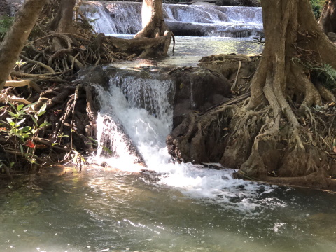
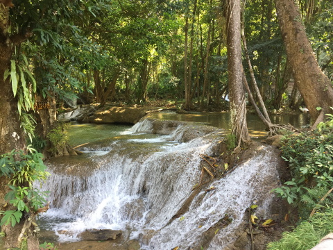
Kroeng Krawia Waterfall The Khao Laem National Park extends into the Thungyai Naresuan Wildlife Sanctuary to the north of Sangkhla Buri and goes all the way to Tak province 200 km to the north. To the north-east the Thungyai Naresuan Wildlife Sanctuary joins the Huai Kha Khaeng Wildlife Sanctuary 130 km away in Uthai Thani forming a contiguous belt of mountains and forest with its protected flora and fauna. 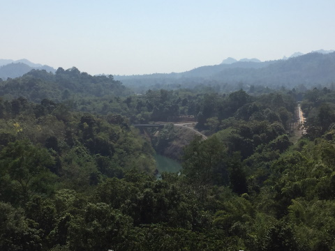
The terrain in the area In 1984, the Vajiralongkorn Dam, built across the Kwae Noi River to the south, created a huge reservoir that looks like a placid lake surrounded by green mountains. The reservoir stretches for 40 km to the north to a small town on the northern shores and that's where we are heading. 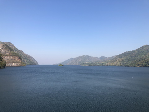
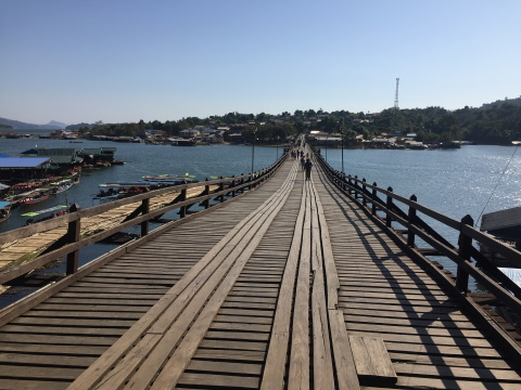
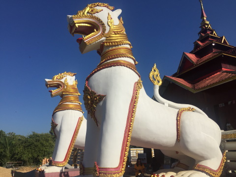
View of the reservoir from the Vajiralongkorn Dam, looking north towards Sangkhla Buri Contents The Mon Bridge The Mon Bridge is a famous attraction in the town of Sangkhla Buri on the northern shores of the reservoir. This wooden trestle bridge with a length of 445 m is the longest wooden bridge in Thailand. 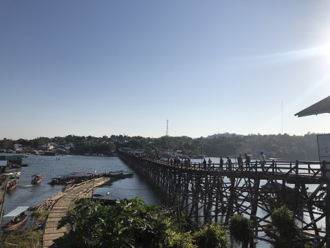
View of the bridge from the northern bank 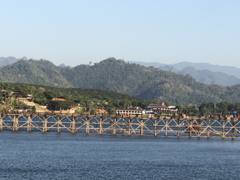
Side view of the Mon Bridge from the Viewing Point south of the Songkalia Bridge 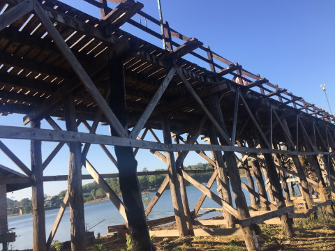
Close-up of the timber trestle supports on the southern bank near Baan Mon The bridge was built between 1986 - 1987 to span the Songkalia River, linking the Karen community in Baan Nam Lai on the northern bank to the Mon community in Baan Wang Ka to the south. This ambitious project was the initiative of the abbot of Wat Wang Wiwekaram, Phra Racha-Udom Mongkol or Luang Por Utama. 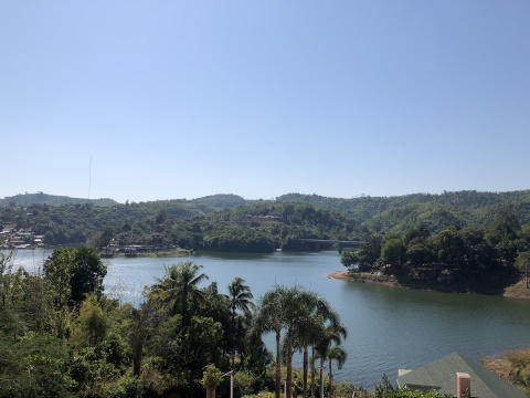
View of the Songkalia River from the northern bank just west of the Mon Bridge (not in photo), the Songkalia Bridge is to the right 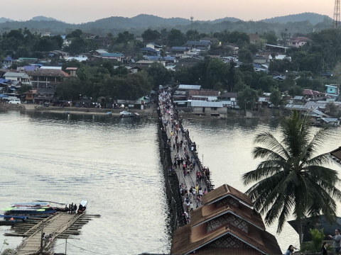
View of Baan Mon located south of the bridge For this reason, the official name for the bridge is Saphan Utamanusorn or the Utama Memorial Bridge. It was a community effort with people living on both banks of the river joining in to complete the bridge within a year. The bridge serves as a vital link between the communities living on both banks for trade, employment, transportation of agricultural products and also for cultural exchange and social interaction. 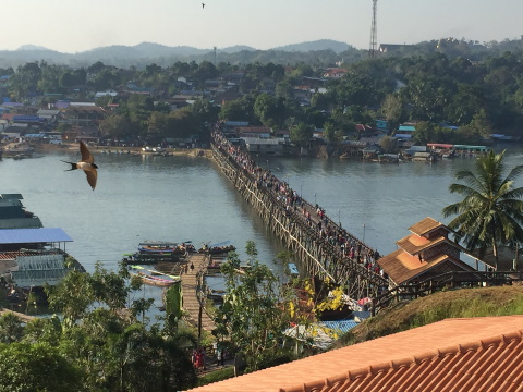
A vital link for trade and social interaction Sam Prasob (sam – three, prasob – confluence, joint) is an interesting geographical feature consisting of the confluence of three rivers; Songkalia, Ranti and Bi Khi Yai to form the Kwae Noi River. As a result, the hillock with its resorts and restaurants, overlooking this feature is also called Sam Prasob. However, the building of the dam in 1984 inundated the area and this confluence is not apparent. 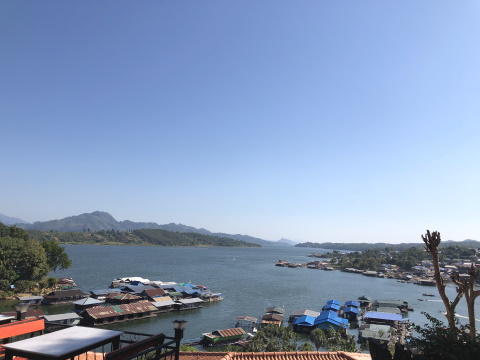
View of the reservoir from the Sam Prasob Resort looking towards where the confluence of the three rivers would have been 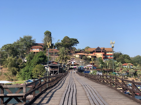
View of the bridge from the south looking towards Sam Prasob Resort On 28 July 2013, after heavy rain for three continuous days, part of the Mon Bridge collapsed resulting in a 30 m gap. To make matters worse, heavy runoff from the Thong Yai Naresuan Wildlife Sanctuary upriver carried uprooted trees downriver. These trees on hitting the trestles of the bridge caused further damage and resulted in a bigger gap of 70 m. 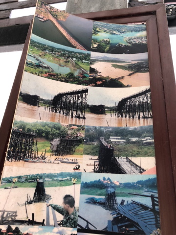
This set of photos shows the extent of damage to the bridge Repairs to the bridge were delayed for a year because the contractor engaged for the task couldn't acquire the timber for the job! However, help came from another sector. With the help of the Combat Engineers from the 9th Infantry Division, Royal Thai Army based in Camp Surasi, Kanchanaburi, members of the communities living around the bridge and donations from the abbot of Wat Wang Wawekaram, the bridge was repaired in 29 days. The opening ceremony of the Mon Bridge was held on 18 October 2014, the 104th anniversary of the birth of Luang Por Utama, with a colourful sight and sound display on the bridge to honour the abbot who initiated the efforts to build the Mon Bridge and community. 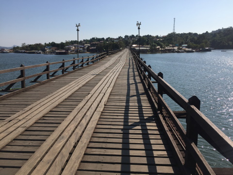
The Mon Bridge in 2019 Early every morning, residents line the bridge to offer alms to the passing monks. It gets busier during holidays, festive seasons when tourists from other parts of Thailand visit the bridge. Contents Baan Mon – the Mon Community Baan Wang Ka or Baan Mon was started in 1947 by 60 Mon households fleeing the war in Burma. The community settled in the Kwae Noi valley on the west bank of the river. The Kwae Noi River just east of the settlement was a large body of water teeming with fish. Hence the settlement was named Wang Ka (wang – body of water, ka - fish, the second word ka is from the Mon language). With the building of the dam in 1984, the residents had to move to the present location as their old settlement would be submerged. Wat Wang Wiwekaram, the Mon temple would also be submerged. The government granted land to the abbot of Wat Wang Wiwekaram to build a new temple and part of this land grant was distributed by the abbot to the Mon to build their new homes. 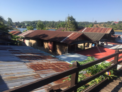
Cluster of houses at the southern end of the bridge Today, Baan Mon, due south of the Mon Bridge, is a bustling community with shops, homestays and hostels. 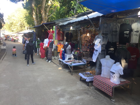
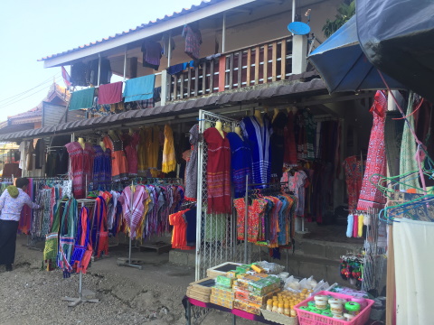
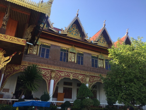
Shops in Baan Mon Contents Wat Wang Wiwekaram – the Mon temple Wat Wang Wiwekaram, the Mon temple was originally located on the slopes of the hill to the west of the Kwae Noi valley. With the construction of the dam, the valley was inundated and the temple was relocated. However, the old temple being on slightly higher ground was not completely submerged. The top of two buildings can still be seen. We will be covering this in our February issue. The new Wat Wang Wiwekaram is beautiful and very different from the temples I have visited in Bangkok and Thailand. 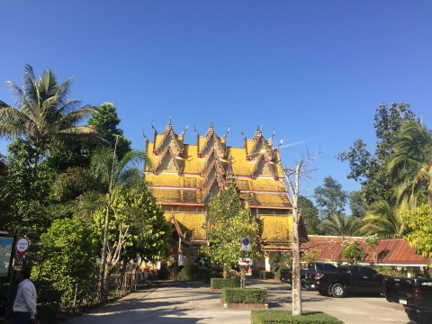
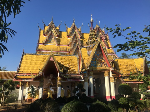
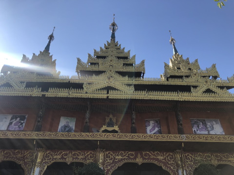
The ubosot of ordination hall The ubosot in glittering gold is adorned multiple tiered gables. The kuti or monks' living quarters has eaves lined with golden floral motifs. 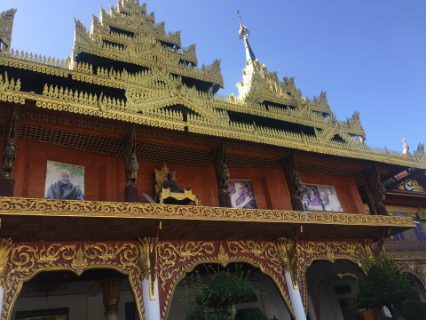
The kuti or monks' living quarters About 900 m to the south-east of Wat Wang Wiwekaram is another impressive structure, the Chedi Buddha Gaya which was modelled after the Buddha Gaya Pagoda in India. 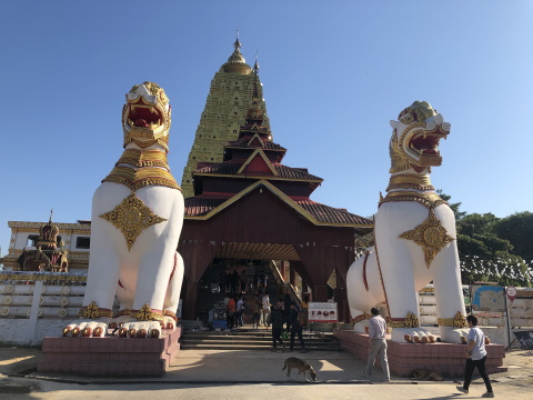
Chedi Buddha Gaya Members of the Mon community pooled their funds and contributed their labour for the construction of this chedi. Construction started in 1982 and here are some interesting facts about the construction of this chedi. 260,000 Mon bricks were used for the construction of the chedi. The Mon brick is of a standard size of 8 inches long, four inches wide and three inches high. The foundations of the chedi consists of a reinforced concrete basement 42 m square and 57 m high. 16 tons of iron posts were used to reinforce the structure. 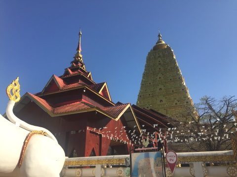
The golden chedi In 1989, two relics of Buddha's right thumb bone originally from Sri Lanka were enshrined in the chedi. HRH Crown Prince Maha Vajiralongkorn (present King Rama X) presided over the ceremony on behalf of King Rama IX. With that friends, we end the first leg of our exploration of Sangkhla Buri. We leave you with these parting shots of the Mon Bridge; the first taken at 7:30 on a chilly morning in early December and the second just after sundown at 6:00 in the evening. 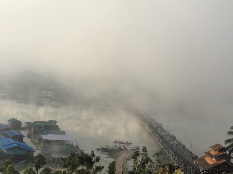
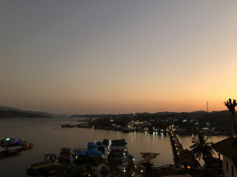
Parting shots and lasting memories Contents Map to Sangkhla Buri If the map doesn’t appear, click on this link How to get there From Bangkok – highway 338 – highway 4 (to Nakhon Pathom) – highway 323 – highway 367 (to bypass Kanchanaburi City if you don't wish to stop there) – re-join highway 323 and continue all the way to the Custom House junction. Do not turn right to continue on route 323. Go straight on, turn left into Soi Si Suwan Khiri, then turn right into Soi Sam Prasob. Once you leave Kanchanaburi city, you will encounter beautiful scenery, forested mountains, hills and valleys all around and the calm waters of the reservoir. A word of caution though, the mountain road has lots of sharp corners, please drive carefully. Where to stay The Sam Prasob Resort is a convenient place to stay as it overlooks the Mon Bridge. If there are just the two of you get a room for about 1,200 baht during the weekend. For bigger families or groups, the chalets are available for about 6,000 baht. Be sure you make your booking in advance. The place will be fully booked over the weekends and long holidays. Opening hours The best time to visit the Mon Bridge is at dawn, from 0600 – 0730 hours and at sundown around 1800 hours. The bridge is open all day and night. Be on the bridge at 0600 if you wish to line up to offer alms to the monks. The Baan Mon is open all day. So is Wat Wang Wiwekaram. Admission Admission to the Mon Bridge and Wat Wang Wiwekaram is free. Have a safe and enjoyable trip! See you next month. Next month we will take a boat trip to locate some of the temples that have been abandoned as a result of the dam flooding the entire Kwae Noi valley. See you then. Contents Next month Boat trip to sunken temples If you enjoyed reading this e-zine, please forward it to a friend. If you received this from a friend and found it interesting, please subscribe at Bangkok Travelbug. What do you think of the Bangkok Travelbug? We love to hear from you What other subscribers have said Till next month then. Eric Lim Tour Bangkok Legacies Find us on Facebook My Journey through Thailand Part I The First Steps This is my second e-book and the first in the series of travel journals on my trips to explore the various provinces in Thailand. This edition, which covers my travels from late 2009 to mid-2013, will guide you to historical sites, cultural monuments and exquisite Thai handicraft, across a vast spectrum of cultural and ethnic diversity. You can have a virtual tour with this e-guide book or take the first steps yourself in this journey through Thailand. My Kindle e-book 
Copyright@2008-2020 Tour Bangkok Legacies All rights reserved
|
| Back to Back Issues Page |