| Back to Back Issues Page |
 |
|
Bangkok Travelbug June 2016 Exploring Muak Lek Saraburi May 26, 2016 |
| Hello
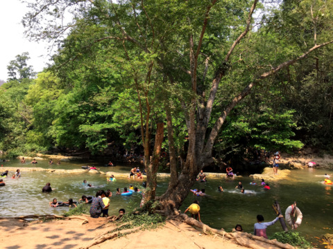
Chet Sao Noi Waterfall Chet Sao Noi Waterfall is formed from five streams with their headwaters in neighboring Khao Yai, flowing through Pak Chong, Nakhon Ratchasima through Muak Lek, Saraburi before joining the Pasak River to the north. The waterfall is in a vast area with forested hills and acquired the status of a national park in 1980. It was discovered during the reforestation project by local officials and was named after the village of Ban Sao Noi to the north. As it has seven tiers, chet (seven) was added. However the official web site of the Department of National Parks mentions another possible reason for this name; that seven young maidens drowned here before, hence chet sao noi. The national park covers 41.5 sq km and stretches over two provinces Saraburi and Nakhon Ratchasima (Korat) under the responsibility of National Parks, Wildlife and Plant Preservation, Ministry of Natural Resources and Environment Owing to the gradual gradient of the terrain in Muak Lek, Chet Sao Noi is a relatively low and slow flowing waterfall. It has seven low tiers instead of a fast flowing river plunging sharply over a steep cliff. Ironically, this has made it safe for swimming. The surrounding area has wide variety of rare plants, a result of the reforestation efforts; actions have also been taken to prevent soil erosion and water pollution. Some of the trees are growing right at the water’s edge. 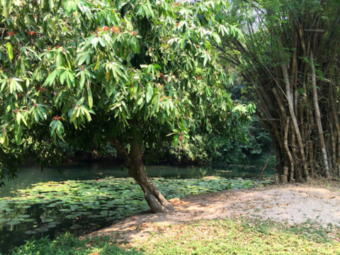
Foliage on the banks This has created a wonderful picnic atmosphere for local residents and visitors who took this opportunity to escape the sweltering heat by dipping in the cool waters or sitting in the shade chatting with friends. 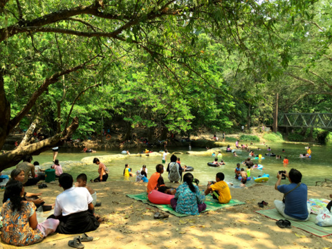
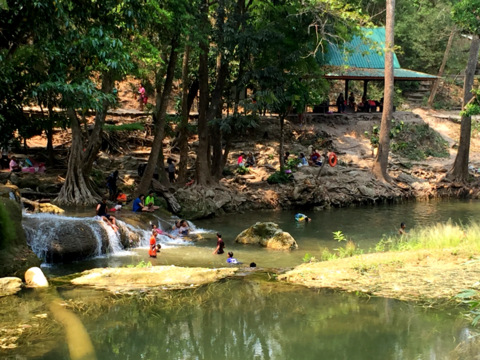
A relaxing picnic site We managed to climb up to the third tier where there is a barbecued chicken vendor and had lunch in a cool shade of the trees amid the gentle gush of water below. 
On the third tier 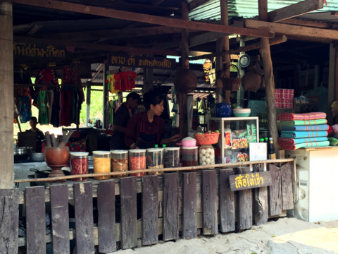
Barbecued chicken, som tam and mats for rent 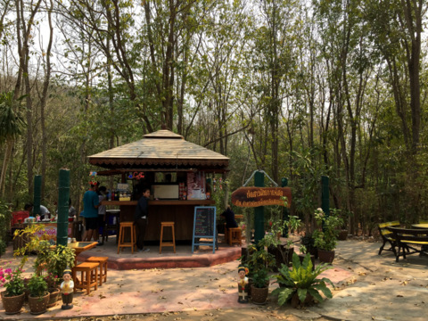
After lunch and a coffee, it was time to hit the road. Contents Wat Pong Takob Archaeological Site Finding this place was by sheer chance, I noticed a sign board along the way indicating an archaeological site at Wat Pong Takob in Tambon Wang Muang to the north. Thankfully these signboards were repeated along the way. Wat Pong Takob School stood across the narrow country road from the temple of the same name. As it was a Saturday, no one was around. The empty school field had a shed at the far end. 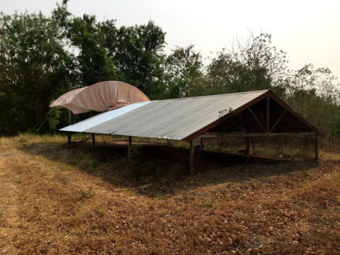
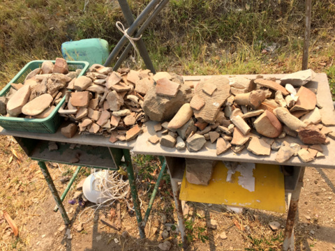
The shed at the far end The shed, just a roof with no walls, covered a big pit with two aluminium boxes inside. Broken pieces of pottery were display on a table next to the pit. 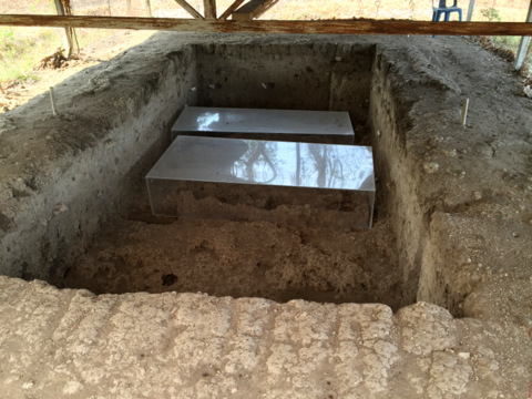
Contents of the pit Fortunately a banner on a building nearby had a phone number to the tambon (sub-district) office. The person at the office directed us to another shed with wire fence all round another pit. There were several human skeletons inside. 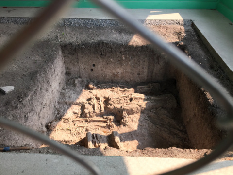
Contents of the second pit The Tambon Wang Muang intends to preserve these pits and build a museum to display the relics. There wasn’t much more information on this site. For enquires for visits in future, please contact Ban Pong Takob Archaeological Site Wat Pong Takob Tambon Wang Muang Amphur Muak Lek Saraburi Telephone: 087 212 8095 Contents Wat Pong Manao Archaeological Site Not to be deterred, I remembered that there was another archaeological site nearby at Wat Pong Manao which is actually in Lopburi just 10 km to the north of where we were. Here we hit the jackpot! Ban Pong Manao in Lopburi is small farming community of about 100 odd households with about 360 people. It’s a relatively new community which was started in 1957. In 2000 a group of outsiders were digging in the area of Ban Pong Manao. Their suspicious behavior caused the residents to call the police who arrested this group. It was discovered that the group was digging for archaeological relics! The community decided to undertake the excavation of the area on their own. From 2001 – 2004 volunteers from the village, local students and archaeology students from the Faculty of Archaeology, Silapakorn University worked in the area. The ten pits were excavated and developed into an open site museum. 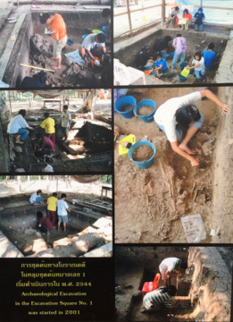
Excavation There are information boards with photos and explanations in Thai and English at the excavation sites which are roofed, fenced and locked. 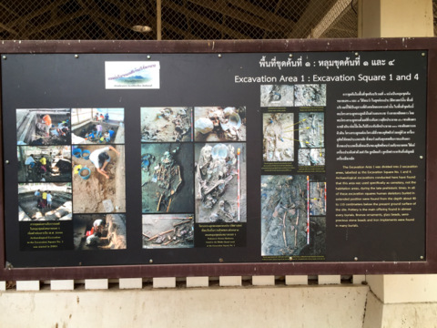
Information board 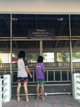
Each excavation site is fenced and locked From the copper and bronze tools discovered and the custom of burying the dead with pots and ornaments, it was concluded that these relics belong to a civilization³ from 2,000 to 3,000 years old similar to the one covered in the Ban Kao National Museum, Kanchanaburi. 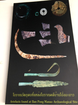
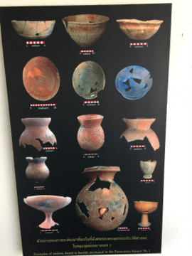
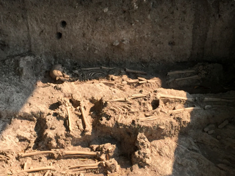
Tools and pottery of that period ³This civilization probably existed in the later part of the Neolithic or New Stone Age which lasted from 6,000 BC - 2,000 BC. This early community had extended burials; mass community graves in which the dead, adults of both sexes and grown up children were buried in rows of shallow graves about 40 – 110 cm below present ground level. Two forms of burials were practised; for adults and still born infants. 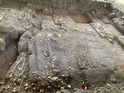
Mass grave after most of the relics have been removed 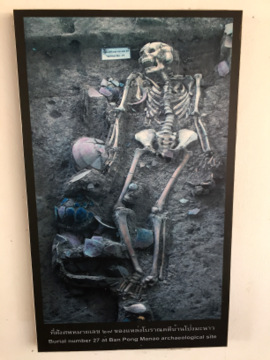
One of the skeletons Broken pieces of pottery were laid on the grave before the bodies were laid in supine positions. Adults were buried with metal tools and weapons, personal ornaments made from glass stone, turtle shells and even the foot of a piglet. Still born infants were kept in large jars and buried near home. 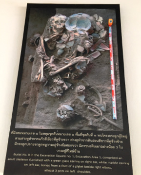
This photo illustrates the burial custom for adults A building was constructed to serve as a museum to house many of the displays. Unfortunately, it was closed during our visit. 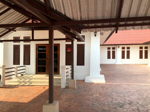
Ban Pong Manao Museum This conservation project, the pride of the Ban Pong Manao Community, has served to protect ancient artifacts and help develop the community through tourism. This is not so much the commercial benefits of tourism but the personal development of the members of the community who are trained as museum guides by archaeology students from the university. During the long school vacation, school children volunteer as guides. This experience gives the students new knowledge and develops confidence in public speaking. From the performance of the three junior guides who conducted our tour of the open site museum, I think they have done very well. A big thank you for the information provided! 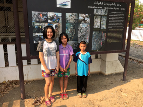
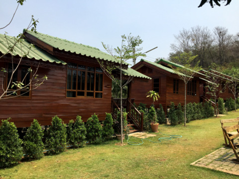
Our young volunteer guides The open site museum is open every day. Admission is free. To view the displays inside the building and for trained guides, please call to make an appointment. Contact Ban Pong Manao Community Museum and Archaeological Site Wat Pong Manao Tambon Huai Khun Ram Amphur Phattananikhom Lopburi Province Telephone: Tambon Administrative Organization – 036 704 024 Ban Pong Manao Village Chief – 094 289 1988 Contents Muak Lek Hillside After visiting a waterfall where seven maidens reputed drowned and two mass burial sites, we decided to call it a day as it was already four in the afternoon. We drove south along highway 2243 towards Pak Chong in Korat to look for accommodation. We didn’t get to Pak Chong that afternoon as we were stopped in out tracks by this stunning sight along the way. 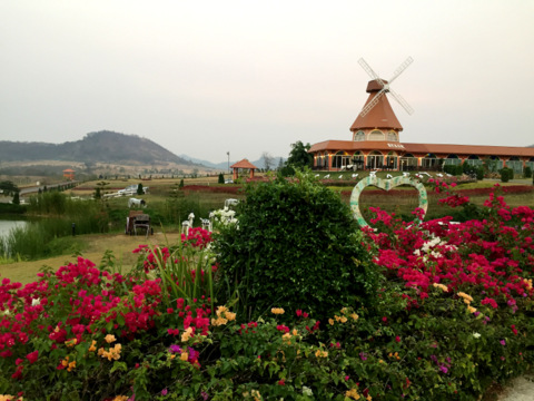
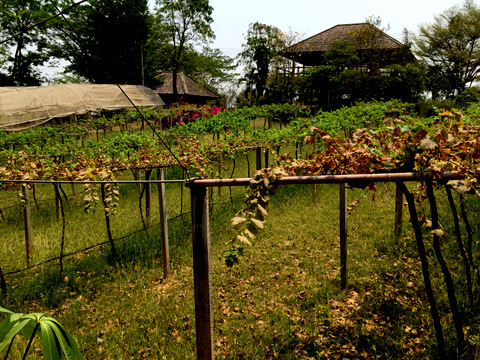
Muak Lek Hillside Here we stayed there for the night as the only guests; outnumbered by the staff. The grounds of the Muak Lek Hillside are beautiful with vast peaceful and well landscaped gardens. 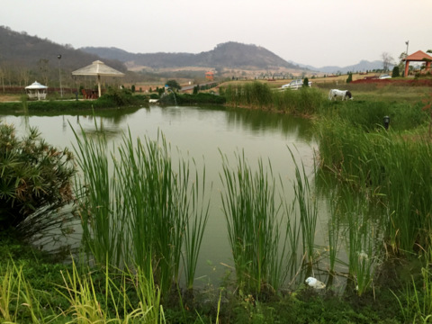
Grounds of the Muak Lek Hillside The restaurant serves good Thai and Western food and the ambience made our dinner and breakfast on the terrace memorable. 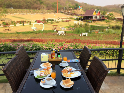
Breakfast on the terrace After breakfast it was on to Pak Chong and highway 2 past Saraburi and back to Bangkok. The route down to Pak Chong has several resorts, motels, restaurants and café. So accommodation is easily available along this scenic route. For enquires please contact Muak Lek Hillside Muak Lek Saraburi Thailand Telephone: 036 346 320, 088 725 8127, 090 427 2594 Muak Lek is a very pleasant district to drive through, visit the various places of natural beauty, stay the night in any of the numerous resorts along the way and drive back to Bangkok the next morning, an enjoyable weekend getaway. This journey through three provinces; Saraburi, Lopburi and Nakhon Ratchasima, is one of stark contrasts. 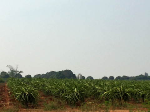
Dragon fruit plantation on the way to Pak Chong Contents Map of Muak Lek Attractions If the map doesn’t appear, click on this link How to get there By car From Bangkok - Vibhawadi Rangsit Road - past Don Mueang Airport - Highway 1 – Saraburi – Highway 2 Route taken; Highway 2, route 2089 to Wang Muang, route 3017 to Wat Pong Takob, route 2273 – 2282 to Wat Pong Manao, 2243 to Muak Lek Hillside and Pak Chong. Contents Next month Historical treasures of Buriram If you enjoyed reading this e-zine, please forward it to a friend. If you received this from a friend and found it interesting, please subscribe at Bangkok Travelbug. What do you think of the Bangkok Travelbug? We love to hear from you What other subscribers have said Till next month then. Eric Lim Tour Bangkok Legacies Find us on Facebook If you are an independent traveller, here's a handy e-guide book, Tour Bangkok Legacies, which will help you along as you explore the streets of Bangkok and discover its old treasures. It's complete with historical descriptions, maps and detailed directions on how to get to these places. My Kindle e-book 
Copyright@2008-2016 Tour Bangkok Legacies All rights reserved |
| Back to Back Issues Page |