| Back to Back Issues Page |
 |
|
Bangkok Travelbug May 2020 Maps of old Siam May 15, 2020 |
| Hello
Siam 1809 In the year 1786, four years into the reign of King Rama I (1782 – 1809), Siam power was on the rise. The massive Burmese invasion was soundly defeated in the Nine Armies War the year before. A second invasion in late 1785/early 1786 was beaten off as well. To the north and east, Siamese rule extended to Champassak, Vientiane and Luang Prabang in present Laos, Phnom Penh, Siem Reap and Battambang in Cambodia. To the south Siamese rule was enforced on Patani while the Malay states of Kedah, Kelantan and Trengganu paid tribute to Siam. In 1794, a Cambodian king loyal to Bangkok by installed by King Rama I. This effectively placed the entire Cambodia under Siamese control. The map below shows the extent of the Siamese Empire in 1809 at the end of the First Reign. Siam was at the zenith of its power. 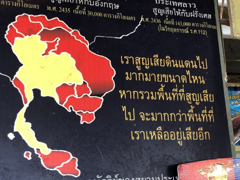
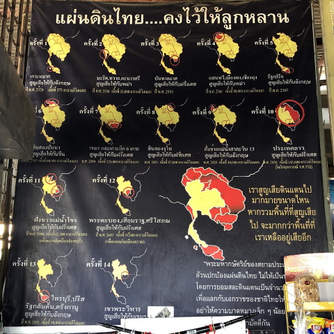
The Siamese Empire consists of areas marked in yellow and red, except for the narrow coastal strip in Burma to the west and the little island off the Malay Peninsula Contents Boundary changes 18th C Please open this map of boundary changes to Thailand 1786 – 1904 in a separate tab for reference to all the events in the following paragraphs. If the map doesn’t appear, click on this link 1. 1786 – cession of Koh Mark In 1786, the Sultan of Kedah ceded the island of Koh Mark off the coast of Kedah to a British explorer who wanted to establish a trading post for the East India Company. That explorer was Sir Francis Light and Koh Mark is the beautiful island of Penang, a state in present-day Malaysia. The Siamese were too pre-occupied with subduing the Malay states to have noticed this attempt by the sultan to seek British protection. It was a harbinger of more to come in the following decades. 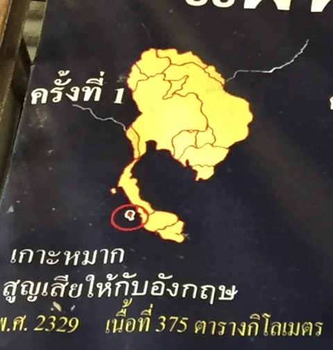
1786 - Cessation of Penang 2. 1793 loss of Myeik, Tavoy (Dawei) and Tanaosi (Thanintharyi) Tavoy (Dawei today) is a city on the banks of the Tavoy River with access to the Andaman Sea. Back in the 1400’s, Ayutthaya controlled it to provide a direct access to the Andaman Sea and trade in the Bay of Bengal. It was lost with the fall of Ayutthaya. Myeik is a coastal town and Tanaosi (Thanintharyi) is on the Thanintharyi River which leads out to the Andaman Sea. Control of these towns provides access to the Andaman Sea. In 1787 King Rama I launched a counter-attack against the Burmese at Tavoy (Dawei) on the coast of Burma. That attack failed and he had to withdraw. Another attempt was made in 1791, this time Siamese occupied the city and held it for two years. In 1793, the Burmese forced the Siamese out. As a result, Siam lost control of the coastal strip between Tavoy and Myeik and with that access to the Andaman Sea. 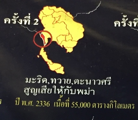
1793 - Loss of the coastal strip and access to the Andaman Sea Contents Boundary changes 19th C 3. 1810 loss of Banthaimas This is the section that gave me the most difficulty. A search for the word Banthaimas in Thai translates to Banteay Meas in Cambodia. I am unable to find any data to verify this event. French colonisation of Cambodia only began in 1863. This event in 1810 doesn’t fit in. However, a Thai website mentions that Banthaimas actually refers to Ha Tien a coastal city in the south-western tip of Vietnam near the Cambodian border. Ha Tien according to the website was part of Siam since the reign of King Taksin. The year 1810 was in the reign of King Rama II when Siam and Vietnam were struggling over control of eastern Cambodia. The Cambodian king was unhappy that Siam controlled the western Cambodian provinces and sought Vietnamese protection. Siam felt it was too weak then to confront the Vietnamese. It could be during this period that Banthaimas or Ha Tien was lost to Vietnam and not France as stated in the map. 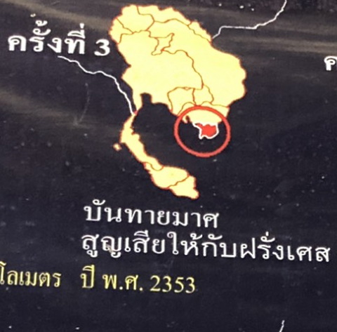
Banthaimas – Ha Tien 4. 1825 loss of Hsenwi, Chiang Tung to Burma Hsenwi or Theinni today (Saen Wi in Thai) is a state in the northern Shan states in Burma. Chiang Tung or Keng Tung is a state in northern Burma. In the late 1700s and early 1800s these northern Burmese states were attacked and brought under the rule of Chiang Mai. With the British colonisation of Burma in 1824, Hsenwi and Keng Tung became part of Burma. 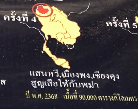
1825 - Hsenwi and Keng Tung became part of British Burma 5. 1826 Burney Treaty In 1824 when King Rama III started his reign, the First Anglo-Burmese War started. Siam had imposed its rule on the Malay state of Kedah (Saiburi in Thai) and was planning to extend their rule over Perak. The war in Burma caused great concern to the Siamese as they feared British designs in the Malay Peninsula. The British wanted to ensure Siamese neutrality and to ease pressure on the Malay states. In late 1825, Sir Henry Gurney was despatched to Bangkok to negotiate a deal. However, in early 1826, the British inflicted a crushing defeat on the Burmese which strengthen their position with Siam. Under threat of war with Britain, the Burney Treaty was signed June 1826. Under this treaty, British recognised Siamese suzerainty over Kedah, Kelantan, Trengganu and Perlis. Siam in return had to recognise the independence of Perak and Selangor. In other words, leave these states alone. This was another push back along the Siamese border by the British. A bigger push was yet to come. 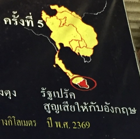
1826 - Hands off Perak and Selangor 6. 1850 Loss of Sip Song Panna to China Sip Song Panna (12 rice townships) refers to a community of Thai Lu living in the area between Southern China and Northern Burma. Suzerainty over this region fluctuated between China and Burma. When Siam defeated Burma in 1786, suzerainty over the region was technically transferred to Siam. In the mid-1800’s China imposed her rule on the region and Sip Song Panna became Xishuangbanna Dai Autonomous Prefecture in Yunnan, Southern China. 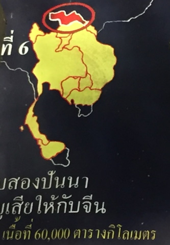
1850 - Sip Song Panna 7. 1867 loss of Cambodia and six off- shore islands to France In 1863, France signed a treaty with Cambodia that placed all Cambodian territory including its off-shore islands under French protection. In 1867, France signed a treaty with Siam giving Siam suzerainty over the western Cambodian provinces of Battambong, Siem Reap and Sisophon. In return, Siam had to renounce all rights of suzerainty over the rest of Cambodia. 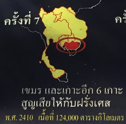
1867 - Cambodia becomes a French protectorate 8. 1888 loss of Sip Song Chau Tai in Laos to France Sip Song Chau Tai (12 Tai principalities) is a confederation of The Tai Dam (Black Tai), Tai Don and Tai Daeng (Red Tai) living in the Black River valley in northern Laos near Dien Bien Phu, Vietnam. In 1888, a French military force from North Vietnam annexed the land to Tonkin (North Vietnam). 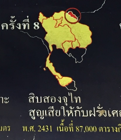
1888 - Loss of Sip Song Chau Tai 9. 1892 Loss of left bank of Salween to Britain I am unable to find specific information to verify this event. I take it that after the British colonised Burma in 1886, they gradually extended their control over various parts of the country. 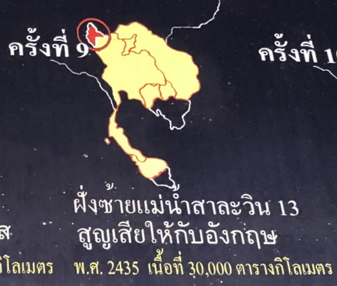
1892 - Loss of left bank of Salween (Thanlyin) River 10. 1893 Loss of Laos east of the Mekong to France In 1893, fighting broke out between the Siamese and French in Laos. The French had ambitions to secure the entire Mekong River in Indochina for a trade route to China. The land battle in Laos gave the French the perfect excuse to declare war on Siam. Gunboats sailed up the Chao Phraya River to bombard Bangkok. Siam sued for peace and one of the punishing conditions was the loss of the whole of Laos east of the Mekong River. France occupied the eastern provinces of Chanthaburi and Trat until all the conditions imposed were met by Siam. 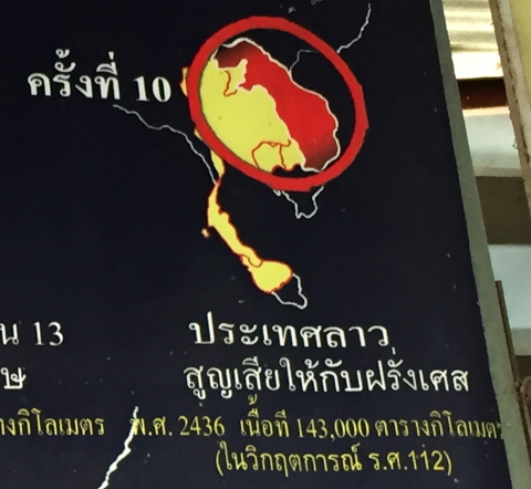
1893 - Loss of Laos east of the Mekong For more on the Franco- Siamese War 1893, please see Paknam – the forts of crouching tigers Contents Boundary changes 20th C 11. 1904 Loss of Laos on the west bank of Mekong to France In an agreement with France in 1904, Siam ceded two areas on the west bank of the Mekong to France:
This treaty was signed in return for the French withdrawal from Chanthaburi and Trat which were occupied after the Franco-Siamese War in 1893. With this, the entire Laos was ceded to France. 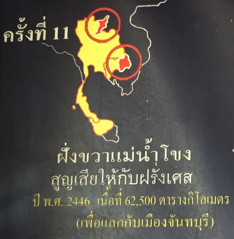
1904 - Complete cessation of Laos 12. 1907 Loss of Battambang, Siem Reap and Sisophon to France Siam complied with the conditions imposed on her in the 1893 treaty with France, but France didn’t keep her end of the bargain. Chanthaburi and Trat remained under French occupation; Chanthaburi was only returned in 1906. In 1907, France imposed an additional condition for the return of Trat; Siam had to cede her rights to the western Cambodian provinces of Battambong, Siem Reap and Sisophon, an act of extreme bad faith. As a result, Siam lost all the territories she used to hold in Cambodia. 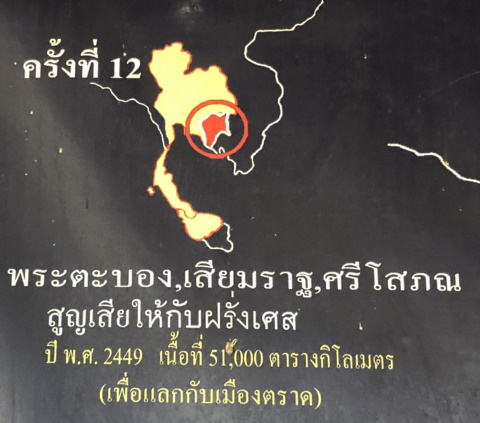
1907 - Loss of western Cambodia 13. 1909 Loss of Kedah, Perlis, Kelantan and Trengganu to the British The final and heaviest blow came from the British. Siam transferred all rights of suzerainty over the Malay states of Kedah, Trengganu, Kelantan and Perlis. It is unclear what pressure was exerted on Siam to do this. In return, British citizens in Siam were now subject to Siamese law, the limit on land tax was removed and Britain had the exclusive rights to build a railway linking Singapore to Bangkok. The Siamese border in the south was pushed back to the current Thai-Malaysian border. 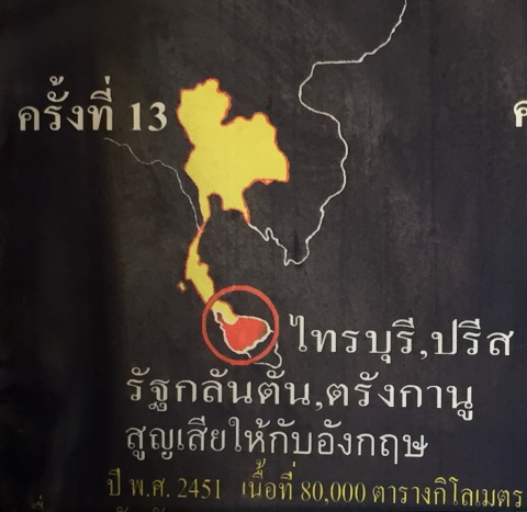
1909 - Cessation the Malay states In the Fifth Reign, Siam managed to retain her independence from two voracious colonial powers at a cost of giving up large swathes of territories all around her. The land lost to the colonial powers amounted to 176,000 square miles or 456,000 square kilometres! The Siamese Kingdom was reduced to half of what it used to be at the end of the First Reign in 1809! 
Area in yellow is what was left of Siam at the end of the Fifth Reign, the areas in red were ceded 14. 1962 loss of Phra Viharn to Cambodia Finally, there was the border dispute over the ownership of the ancient temple Preah Vihear (Phra Viharn in Thai) on the Thai-Cambodian border. The conflict was a legacy of differing versions of maps left behind by the French delineating the borders. In 1962, the conflict was brought before the International Court of Justice which ruled in Cambodia’s favour. Between 2008 – 2011, there were several exchanges of fire between Thai and Cambodian troops across the border. In 2013, the International court of Justice ruled that the land east and west of the temple belonged to Cambodia and Thai troops had to withdraw from the area. 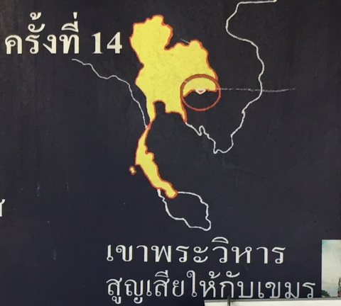
1962 - ICJ rules that Phra Viharn belongs to Cambodia To end this account about borders, I’d like to recall a court case about borders. In the early 2000s a community of Karen were charged for illegally crossing the border into Thailand. Their defence counsel called a professor of Thai history as a defence witness. This is the gist of the professor’s testimony. “After the fall of Ayutthaya, our borders were pushed right back to the coastal strip in Central and Eastern Thailand. In the reigns of King Taksin and King Rama I, we expelled the Burmese and pushed our borders out over to the Burmese side. The same applied to our borders with Cambodia and Laos. Then Britain and France came and pushed our borders back in again. This community of Karen have been living in their village for generations. They haven’t lived anywhere else. They didn’t cross the border, the border crossed them!” The case was dismissed. Well done, Prof! Contents Map to Khao Kaeng Sian Lor If the map doesn’t appear, click on this link How to get to Khao Kaeng Sian Lor Khao Kaeng Sian Lor is 17 km north of Ayutthaya along Route 32. From Bangkok take the Don Muang Tollway – Highway 1 – Route 32. Look out for this signboard. 
Khao Kaeng Sian Lor For next month, let me search through my old travel photos to see if I can dig up something interesting. Please stay well, stay safe and stay home! “Reading gives us some place to go when we have to stay where we are”. Mason Cooley (1927 – 2007) American aphorist* *A person who expresses concise, memorable and wise sayings, called aphorisms. Contents Next month Old travel photos. If you enjoyed reading this e-zine, please forward it to a friend. If you received this from a friend and found it interesting, please subscribe at Bangkok Travelbug. What do you think of the Bangkok Travelbug? We love to hear from you What other subscribers have said Till next month then. Eric Lim Tour Bangkok Legacies Find us on Facebook My Journey through Thailand Part I The First Steps This is my second e-book and the first in the series of travel journals on my trips to explore the various provinces in Thailand. This edition, which covers my travels from late 2009 to mid-2013, will guide you to historical sites, cultural monuments and exquisite Thai handicraft, across a vast spectrum of cultural and ethnic diversity. You can have a virtual tour with this e-guide book or take the first steps yourself in this journey through Thailand. My Kindle e-book 
Copyright@2008-2020 Tour Bangkok Legacies All rights reserved |
| Back to Back Issues Page |